Tampilkan postingan dengan label East Nusa Tenggara. Tampilkan semua postingan

Senin, 28 Maret 2011

The beauty of Komodo Island


The presence of the Komodo National Park which is one of the popular vote competition nominator "New 7 Wonder" is quite inviting charm. The controversy that accompanied the event certainly had no effect on the intensive efforts to continue to preserve the park established in 1986 by UNESCO as world heritage site.

Komodo National Park is located between the Province of West Nusa Tenggara and East Nusa Tenggara It includes three large islands of Komodo, Rinca, and Padar, and several small islands with a land area covering 603 km ² and the total area is 1817 km ². Administratively, this region lies in the subdistrict of Komodo, West Manggarai regency, East Nusa Tenggara Province. National Parks are designated as forest conservation area by the Minister of Forestry with 132 572 ha area was originally established with the aim of conserving species of giant lizard dragons or a unique and rare

Komodo dragons are known by the scientific name Varanus komodoensis is the world's largest lizard species that live on the island of Komodo, Rinca, Flores, Gili Motang, and Gili Dasami in Nusa Tenggara. By local people, dragons are often called Ora.

Including family members Varanidae monitor lizards, and Toxicofera klad, dragons are the largest lizards in the world, with an average length of 2-3 m. Large size is associated with symptoms of island gigantism, the tendency for body meraksasanya certain animals that live in small island linked to the absence of mammalian carnivores on the island where dragons live, and the rate of metabolism of small dragons. Because of his body, these lizards occupy the position of a top predator that dominates its place of living ecosystems.

Komodo dragons are found in 1910. Her body is great and terrible reputation makes them popular in zoos. Dragons in the wild habitat has shrunk and therefore IUCN include dragons as a species vulnerable to extinction. These large lizards are protected under Indonesian law and a national park was established to protect them.

Actually the Park attraction not solely by the mere presence of dragons. As I quoted from the official website of the Ministry of Forestry who manages this site Komodo National Park, panoramic underwater views of savanna and attract potential supporters. Eg marine tourism, fishing, snorkeling, diving, canoeing, boating. While on land, natural tourism potential that can be done is to observe wildlife, hiking, and camping. Visiting the Park and enjoy the natural scenery is very charming an experience that will never be forgotten.

Some interesting sites to visit include:

1. Loh Liang: a tourism concession area managed by PT. Putri Naga Komodo (PNK PT.). Activities that can be done among other observations the Komodo dragon, deer, wild boar, bird watching, canoeing, etc..

2. Red Beach: a beautiful beach with shallow coral reefs charming. Activities usually carried out by tourists who visit are snorkelling or sunbathing.

3. Loh Sebita: Loh Sebita a mangrove area and the activity is quite interesting to do is bird watching and trekking.

4. Loh Buaya: a tourism concession areas dielola by PT. Putri Naga Komodo (PNK PT.). Activities that can be done among other observations the Komodo dragon, deer, buffalo, birds, long-tailed monkey, wild horses, birdwatching, canoeing, etc..

5. Bat Island: Activities that can be visited include the observation colony of bats in large numbers. The most interesting observation made ​​during the afternoon where the bats started to come out to look for food.

6. Golo Code: From the top of the hill, known as Code Golo, visitors can see a panorama and a landscape that is fantastic because the representation of various types of ecosystems can be seen from this place.

7. Molo Strait: Strait which has a heavy flow like river water flowing at high tide.

There are 36 dive sites in the area of ​​TN. Komodo. Frequented by foreign tourists for diving and snorkeling are: Tatawa Island, Red Beach, Gililawa Sea, Loh Dasami, Pillar Steen, Batu Bolong and Taka Napier.

To reach this place can be done via the road through land through Bali - Mataram (Lombok Island) - Bima - Sape (Sumbawa P.), followed by a trip using the ferry every day to Labuan Bajo. From Labuan Bajo visitors can visit the Komodo National Park aboard the boat or speedboat. Another alternative is by air, visitors can use air transportation from Bali (Denpasar) to Labuan Bajo every day with the existing penerpangan airlines including; Indonesian Air Transport (IAT), Pigeon, and Trigana Air.

Source reading: Site www.dephut.go.id and Wikipedia Indonesia
Continue Reading...

Beach megaliths are located in West Sumba


Southwestern Sumba show its beauty through Kampung Ratenggaro. The village is special because it is situated on a cliff on the beach Ratewoyo. Its position overlooking the sea with huge waves breaking reef. Straight ahead, no more land until we came to Africa.

The village was originally located on the headland that is located right by the beach. But the tide causing abrasion and water into the house, so the residents decided to move the village to a higher cliff.

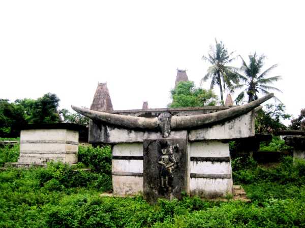
In the former village on the beach still remains a collection of megalithic stone graves. The shape is different from the graves of stone slabs piled like in the town of Waikabubak. The tomb stones here are made of stone intact with more than two meters high and decorated with writings and ancient drawings.

Sitting next to an ancient stone tomb with a beautiful beach watching the waves crashing, I understand why so adored will Sumba cultural richness and natural beauty. Soft white sandy beach flanked by rocks and high cliffs remind me of the Tanah Lot in Bali. Of course, the beach is far more beautiful and very quiet. Unfortunately I came when cloudy so could not watch the sunset.

On the beach I met old man named Thomas who play traditional musical instruments made ​​of wood. Excerpt dawainya add a sense of feel magical atmosphere in the place. Fatigue due to travel by bike for two hours straight loss.


The village is located in Kodi, West Sumba. Kodi is on the western tip of the island of Sumba. This place is about 80 kilometers from the city where I stay, Waikabubak. Viewed in this roadmap a little play, but this is the way the conditions are best.

This time I was escorted by a guide named Timothy Pingge, a native of Sumba. Although he says the way we passed the best condition, still we need to go through puddles and potholes road. Throughout the trip we met a group of school children who smile and friendly greeting every rider who passed them. "Afternoon mother, father day," they said. Rain clouds hanging so many times we had to take shelter from the rain.

Rice fields, houses on the roadside with a grave stone in the yard, ravine and forest into a wonderful treat for the eyes along the journey. Before leaving, we bought a souvenir of the villagers. Rooms for the gentlemen, betel nut for the mothers and candy to the kids.

Living in such a beautiful area had little effect on the welfare of villagers. Segelitir only from those who make a living from the sea. Moreover, this village consists of only five traditional houses. Fires burned four years ago almost all houses in the village. Of the 13 houses, only one survivor.

Indigenous Villages Sumba did have a high fire risk. Roofs made ​​of thatch flammable in the dry season. The fire spread in the wind, so the fires usually destroy all houses in the region.

Rebuilding the custom house was not cheap. Villagers told me that a house requires four main pillars to remain standing. "One timber cost the same as a buffalo, "said the occupants of the village. That's just the cost for the main mast, not counting the cost to build the walls, floor and roof. Besides the costs, the materials are easily obtained from the original forest is now increasingly difficult to find.

Next I visited the Kampung Paronabaroro. The condition of villages in this region is different from the village that I browse in the town of Waikabubak earlier. Remote location that makes this village is still very simple. Marapu belief still held closely by its residents.

The old woman topless wearing a cloth. Men and women chew betel nut which makes them red saliva kesumba. This custom began in teens and make the lips look like wearing red lipstick. Horses tied to the side of the house as a symbol of social status.

The entrance to this village along a path about 4 miles. At the front of the village there is a full clearing the newer grave stone. Some have been modified by using cement, stone is no longer intact.

Grave stones with older age is located in the center of the village. The complex surrounds a grave stone altar where the conduct traditional ceremonies. Not just anyone can set foot into places that are considered sacred.

Electricity had just entered the region in late January. The power source comes from the generator fuel is filled by a joint venture with several villages in the vicinity. To save money, they only use it at night.-Yahoo.com
Continue Reading...
 

Information enchanting beauty of Indonesia Copyright © 2009 WoodMag is Designed by DesainYuk for Indonesian-charm